Koh Chang, Trat, Thailand Koh Chang With no less than 50 offshore isles, Koh Chang boasts the finest red gems, sweet Rakam fruits, indigenous dogs, the historic Koh Chang Naval engagement, and is the eastern-most province in Thailand.Koh Chang (Elephant Island) is Thailand’s second largest island and the primary destination for those visiting Koh Chang Marine National Park, which includes dozens of unspoiled islands. Located in Trat Province, about 300 kilometers East of Bangkok and not far from the Cambodian border, Koh Chang is 70% covered by unspoiled rainforest and the island’s 5000 permanent residents are only gradually becoming more involved in tourism as development has increased in the past decade.Now serviced by an airport just 15 minutes from the ferry terminal in Trat, Koh Chang is more easily accessible than ever before. Drawn to Koh Chang’s pristine beaches and sparkling water, more well-to-do Thai and international travelers have been discovering Koh Chang and numerous luxury spas and resorts have sprung up to cater to them. Nonetheless, the island is still a dream destination for budget travelers and families, with a wide variety of affordable accommodation options and numerous gorgeous and tranquil beaches surrounded by crystal clear water.While the number of tourists has increased, particularly among middle class Thais, Koh Chang is still predominately unspoiled forests and pristine beaches. In addition to natural beauty, the island is also home to a wide range of wildlife, including native birds, snakes, deer, and even a number of elephants. As for activities, Koh Chang and the nearby islands that make up the national park are great for snorkeling, diving, camping, and jungle hiking. The majority of tourists stay at Haad Sai Khao, Haad Kai Mook, Haad Ta Nam, and Laem Bang Bao, all of which are linked by a single road running down the west coast. Access to the island is via Bangkok Airways service to Trat or buses that connect to shuttle service to the ferry docks at Laem Ngop near Trat.Once the quiet refuge of backpackers in the know, Koh Chang (Elephant Island) has grown in popularity as a tourist destination since 2000, when the Thai government hoped to develop the island as the next Phuket. Fortunately, as Koh Chang is nearly as large as Phuket, a decade of development that has seen the construction of an airport in Trat and numerous hotels and restaurants has done little to sully its appeal as an island of spectacular natural beauty. Koh Chang, the largest island in the Koh Chang Marine National Park, is a beach lover and nature enthusiasts dream come true. While recent development has led to the opening of some nightlife on the island, the primary attractions on the island are the beaches, waterfalls, and neighboring islands. However, several fishing villages, a number of naval battle sights, and some opportunities for diving and snorkeling make Koh Chang both an interesting and relaxing place to visit.Key Tips Koh Chang is approximately 30 km long and 14 km wide: a total area of roughly 217 km². The Koh Chang National Marine Park covers an area of 650 km², of which 70 % is offshore.
:: tourismthailand.org ::
2. ถ้ำหินอ่อนมหาวิหาร (The marble cathedral) หนึ่งใน ถ้ำที่สวยที่สุดในโลก ตั้งอยู่ในทะเลสาบ General Carrera ประเทศชิลี
Shared by Argentina and Chile the deepest lake in South America is famous for its trout and salmon fishing. The waters of General Carrera Lake are beautiful, a glittering combination of emerald, turquoise, aquamarine and azure. The sky may be blue but the waters seem bluer still.
However along its banks, directly below the Andes, sheer marble cliffs present themselves to further astound the visitor. Over the millennia they have been weathered and folded to create a stunning cathedral of marble.
From a distance the lake looks magnificent, although when you get closer its dazzling beauty becomes ever more apparent. The passageways and caverns formed over vast stretches of time are sometimes large enough for small boats to glide through. Albeit precariously. It does not take long to become enchanted by Las Cavernas de Marmol as this exquisite labyrinth is known locally. Perhaps even the most cynical jaw might drop at this majestic sight.
As well as being the deepest lake in South America, General Carrera Lake is the biggest lake in Chile with a surface area of almost a thousand square kilometers. It is 200 km long, at an altitude of 350 meters and has a maximum depth of 590 meters. It is known as Lake Buenos Aires by the Argentineans.
The marble protrusions stretch along a beachside and are around 300 meters in length. The waters of the lake have slowly impacted upon the marble and, in their infinite patience, have created something of enormous, almost bewildering beauty. The rock manifests different tones which are dependent upon the natural impurities within the marble. Although the white banks, of immense purity are predominant blue and pink marble banks can also be seen due to the presence of other minerals within the rock.
Strictly speaking, although the Marble Cathedral is spoken of as one formation, in truth it is three. The largest is El Catedral – the Cathedral. There are two smaller formations which are known as La Capilla – the Chapel which rise from the lake, and La Cueva - the Cave.
It has been estimated that these vast sections of marble weigh 5000 million tonnes and consist of 94% calcium carbonate. The area is not in the one of the most hospitable areas of the world but it is lucky. Although the region is cold and humid the lake enjoys a sunny microclimate. So although you may be cold getting there, once you are there you should be warm!
Although the lake has been known by Europeans for little over a hundred years, they were not the first to discover the beauties of the lake. The indigenous people of the region, the Tehuelches, a once nomadic tribe also known as the Patagons have inhabited the region for thousands of years. Their name means the fierce people. They must have been to make their way through the isolated strips of plains through which the lake can be accessed on the Argentinean side.
These stunning pictures represent quite an achievement on behalf of the photographers. Not only are the caves difficult to reach but the lake itself, being so large, can develop swells and waves which make photography quite a challenge. Often, as only small boats can navigate the caves, the journey becomes impossible after a certain point. Although this would, perhaps, be one of the most beautiful places on earth in which to expire, most photographers are somewhat reluctant to embrace this destiny.
Buddha Park, also known as Xieng Khuan (as well as other variations of the spelling), is a sculpture park located 25 km southeast from Vientiane, Laos in a meadow by the Mekong River. Although it is not a temple (Wat), the park may be referred to as Wat Xieng Khuan (Lao: ວັດຊຽງຄວນ;Thai: วัดเซียงควน), since it contains numerous religious images. The name Xieng Khuan means Spirit City. The park contains over 200 Hindu and Buddhist statues. The socialist government operates Buddha Park as a tourist attraction and public park.
The park was started in 1958 by Luang Pu (Venerable Grandfather) Bunleua Sulilat. Luang Pu Bunleua Sulilat was a priest-shaman who integrated Hinduism and Buddhism. His unique perspective was influenced by a Hindu rishi under whom he studied in Vietnam.[5] After the revolution in 1975, he fled from Laos to Thailand where he built another sculpture park, Sala Keoku in Nong Khai. He fled because his anti-Communist beliefs conflicted with the views of the Pathet Lao.[5] After Luang Pu Bunleua Sulitat left, the state took control of his garden and made it into a public park.
The statues are made of reinforced concrete and are ornate, and sometimes bizarre, in design.The statues appear to be centuries old, though they are not. There are sculptures of humans, gods, animals, and demons. There are numerous sculptures of Buddha, characters of Buddhist beliefs like Avalokiteshvara, and characters of Hindu lore, including Shiva, Vishnu, and Arjuna.These sculptures were presumably cast by unskilled workers under the supervision of Luang Pu Bunleua Sulilat. One notable sculpture resembles a giant pumpkin. It has three stories representing three levels - Hell, Earth and Heaven. Visitors can enter through an opening which is a mouth of a 3-metre-tall demon head (9.8 ft) and climb staircases from hell to heaven. Each story contains sculptures depicting the level. At the top, there is a vantage point where the entire park is visible. Another sculpture, an enormous 120-metre-long (390 ft) reclining Buddha, is also a park attraction.
:: travel.thaiza.com :: :: Wikipedia, the free encyclopedia ::
Sigiriya Sigiriya (Lion's rock, Sinhalese - සීගිරිය) is a large stone and ancient rock fortress and palace ruin in the central Matale District of Sri Lanka, surrounded by the remains of an extensive network of gardens, reservoirs, and other structures. A popular tourist destination, Sigiriya is also renowned for its ancient paintings (frescos), which are reminiscent of the Ajanta Caves of India. It is one of the eight World Heritage Sites of Sri Lanka.
Sigiriya may have been inhabited through prehistoric times. It was used as a rock-shelter mountain monastery from about the 5th century BC, with caves prepared and donated by devotees of the Buddhist Sangha. According to the chronicles as Mahavamsa the entire complex was built by King Kashyappan (477 – 495 CE), and after the king's death, it was used as a Buddhist monastery until 14th century. The Sigiri inscriptions were deciphered by the archaeologist Senarath Paranavithana in his renowned two-volume work, published by Cambridge, Sigiri Graffiti and also Story of Sigiriya.
History In 477 CE, prince Kashyapa seized the throne from King Dhatusena, following a coup assisted by Migara, the king’s nephew and army commander. Kashyapa, the king’s son by a non-royal consort, usurped the throne from the rightful heir, Moggallana, who fled to South India. Fearing an attack from Moggallana, Kashyapa moved the capital and his residence from the traditional capital of Anuradhapura to the more secure Sigiriya. During King Kashyapa’s reign (477 to 495), Sigiriya was developed into a complex city and fortress. Most of the elaborate constructions on the rock summit and around it, including defensive structures, palaces, and gardens, date back to this period.
Kashyapa was defeated in 495 by Moggallana, who moved the capital again to Anuradhapura. Sigiriya was then turned back into a Buddhist monastery, which lasted until the 13th or 14th century. After this period, no records are found on Sigiriya until the 16th and 17th centuries, when it was used as an outpost of the Kingdom of Kandy. When the kingdom ended, it was abandoned again. The Mahavamsa, the ancient historical record of Sri Lanka, describes King Kashyapa as the son of King Dhatusena. Kashyapa murdered his father by walling him up alive and then usurping the throne which rightfully belonged to his brother Mogallana, Dhatusena's son by the true queen. Mogallana fled to India to escape being assassinated by Kashyapa but vowed revenge. In India he raised an army with the intention of returning and retaking the throne of Sri Lanka which he considered to be rightfully his. Knowing the inevitable return of Mogallana, Kashyapa is said to have built his palace on the summit of Sigiriya as a fortress and pleasure palace. Mogallana finally arrived and declared war. During the battle Kashyapa's armies abandoned him and he committed suicide by falling on his sword.
Chronicles and lore say that the battle-elephant on which Kashyapa was mounted changed course to take a strategic advantage, but the army misinterpreted the movement as the King having opted to retreat, prompting the army to abandon the king altogether. It is said that being too proud to surrender he took his dagger from his waistband, cut his throat, raised the dagger proudly, sheathed it, and fell dead.[citation needed] Moggallana returned the capital to Anuradapura, converting Sigiriya into a monastery complex.
Alternative stories have the primary builder of Sigiriya as King Dhatusena, with Kashyapa finishing the work in honour of his father. Still other stories have Kashyapa as a playboy king, with Sigiriya a pleasure palace. Even Kashyapa's eventual fate is uncertain. In some versions he is assassinated by poison administered by a concubine; in others he cuts his own throat when isolated in his final battle.[7] Still further interpretations have the site as the work of a Buddhist community, with no military function at all. This site may have been important in the competition between the Mahayana and Theravada Buddhist traditions in ancient Sri Lanka. The earliest evidence of human habitation at Sigiriya was found from the Aligala rock shelter to the east of Sigiriya rock, indicating that the area was occupied nearly five thousand years ago during the Mesolithic Period.
Buddhist monastic settlements were established in the western and northern slopes of the boulder-strewn hills surrounding the Sigiriya rock, during the 3rd century BC. Several rock shelters or caves were created during this period. These shelters were made under large boulders, with carved drip ledges around the cave mouths. Rock inscriptions are carved near the drip ledges on many of the shelters, recording the donation of the shelters to the Buddhist monastic order as residences. These were made within the period between the 3rd century BC and the 1st century CE.
:: ceansmile.com :: :: Wikipedia, the free encyclopedia ::
Hashima Island (端島?, or correctly Hashima, as -shima is Japanese for island), commonly called Gunkanjima (軍艦島; meaning Battleship Island), is one among 505 uninhabited islands in the Nagasaki Prefecture about 15 kilometers from Nagasaki itself.
History The island was populated from 1887 to 1974 as a coal mining facility. The island's most notable features are the abandoned concrete buildings and the sea wall surrounding it. The island has been administered as part of Nagasaki city since 2005; it had previously been administered by the former town of Takashima. It is known for its coal mines and their operation during the industrialization of Japan. Mitsubishi bought the island in 1890 and began the project, the aim of which was retrieving coal from undersea mines. They built Japan's first large concrete building (9 stories high),[1] a block of apartments in 1916 to accommodate their burgeoning ranks of workers (many of whom were forcibly recruited labourers from other parts of Asia) and to protect against typhoon destruction. According to a South Korean commission, the island housed 500 Koreans who were forced to work between 1939 and 1945, during World War II.
In 1959, the 15-acre (6.1 ha) island's population reached its peak of 5,259, with a population density of 835 people per hectare (83,500 people/km2, 216,264 people per square mile) for the whole island, or 1,391 per hectare (139,100 people/km2) for the residential district.
As petroleum replaced coal in Japan in the 1960s, coal mines began shutting down all over the country, and Hashima's mines were no exception. Mitsubishi officially announced the closing of the mine in 1974, and today it is empty and bare, which is why it is called Ghost Island.Travel to Hashima was re-opened on April 22, 2009 after 35 years of closure.
Etymology Battleship Island is an English translation of the Japanese nickname for Hashima Island, Gunkanjima (gunkan meaning battleship, jima being the rendaku form of shima, meaning island). The island's nickname came from its apparent resemblance to the Japanese battleship Tosa (so much so, in fact, it was torpedoed by the American Navy during World War II).It also is known as the Ghost Island.
:: marumura.com :: :: Wikipedia, the free encyclopedia ::
Iguazu Falls, Iguassu Falls, or Iguaçu Falls (Portuguese: Cataratas do Iguaçu [kataˈɾatɐz du iɡwaˈsu]; Spanish: Cataratas del Iguazú [kataˈɾatas ðel iɣwaˈsu]; Guarani: Chororo Yguasu [ɕoɾoɾo ɨɣʷasu]) are waterfalls of the Iguazu River located on the border of the Brazilian State of Paraná and the Argentine Province of Misiones. The falls divide the river into the upper and lower Iguazu. The Iguazu River originates near the city of Curitiba. It flows through Brazil for most of its course. Below its confluence with the San Antonio River, the Iguazu River forms the boundary between Brazil and Argentina.
The name "Iguazu" comes from the Guarani or Tupi words y [ɨ], meaning "water", and ûasú [waˈsu], meaning "big". Legend has it that a god planned to marry a beautiful woman named Naipí, who fled with her mortal lover Tarobá in a canoe. In rage the god sliced the river, creating the waterfalls and condemning the lovers to an eternal fall. The first European to find the falls was the Spanish conquistador Álvar Núñez Cabeza de Vaca in 1541.
:: Wikipedia, the free encyclopedia ::
7. สระว่ายน้ำของ ลีเมอริเดียน อัลอากาห์บีชรีสอร์ท, อัล อาคาห์, สหรัฐอาหรับเอมิเรตส์ (Le Meridien Al Aqah Beach Resort, Dibba Road, P.O. Box 3070, Al Aqah,United Arab Emirates)
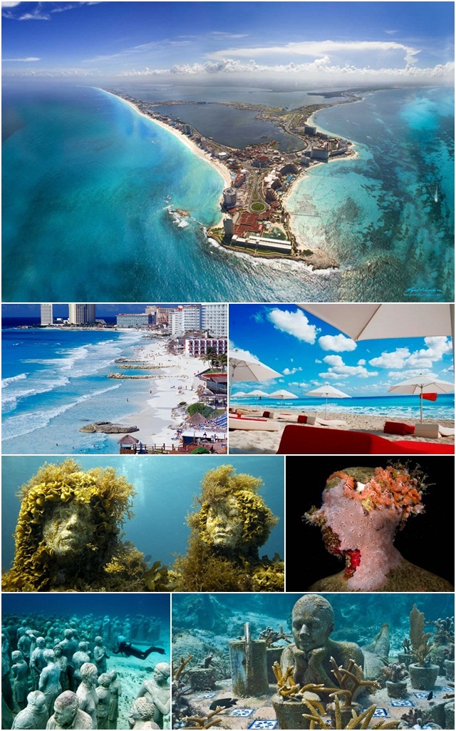
โดยทางองค์กร ได้เริ่มโครงการพัฒนากังกุนให้เป็นเมืองท่องเที่ยวนานาชาติตั้งแต่ปี 1974 หลังจากนั้นเป็นต้นมา กังกุนได้เปลี่ยนจากเกาะสำหรับนักตกปลาเล็กๆ มาเป็นหนึ่งในสองสถานที่ท่องเที่ยวยอดนิยมที่เต็มไปด้วยรีสอร์ต ควบคู่กันกับเมืองอากาปุลโก (Acapulco) WTO (World Tourism Organization) ได้มอบรางวัล Best of the Best ในด้านความยอดเยี่ยมและการปกครองที่ดีเลิศแก่เมืองกังกุน เมื่อปี 2007
Cancún (Spanish pronunciation: [kaŋˈkun]) is a city in south-eastern Mexico, located on the north-east coast of the Yucatán Peninsula in the Mexican state of Quintana Roo. It is a world-renowned tourist destination,as well as being the seat of the Benito Juárez municipality. The city is located off of the Caribbean Sea, and is one of the eastern-most points in Mexico. Cancún is located near/in Mexico's Caribbean coast resort band known as the Riviera Maya.
Place names There are two possible translations of Cancún, based on the Mayan pronunciation. The first translation is "nest of snakes or pot." The second version and less accepted is "place of the golden snake"[citation needed].
Svartifoss (Black Fall) is a waterfall in Skaftafell National Park in Iceland, and is one of the most popular sights in the park. It is surrounded by dark lava columns, which give rise to its name. The hexagonal columns were formed inside a lava flow which cooled extremely slowly, giving rise to crystallization. Similar well-known lava formations are seen at the Giant's Causeway in Northern Ireland, and on the island of Staffa in Scotland.
The base of this waterfall is noteworthy for its sharp rocks. New hexagonal column sections break off faster than the falling water wears down the edges. These basalt columns have provided inspiration for Icelandic architects, most visibly in the Hallgrímskirkja church in Reykjavík, and also the National Theatre.
:: Wikipedia, the free encyclopedia ::
11. A snapshot from mountaineer's life
Location: Chamonix, Haute Savoye, France
Photo and caption by Kamil Tamiola Have you ever wondered how does a mountaineer's day start? I will give you a hint: you wake up at 3 am, set the stove, wake up your partner, pretend it is warm, quickly consume a high-calorie breakfast, watch your friends slowly ascending the icy slopes of your dream summit with their tiny head torches glimmering against perfectly blue ice, and hope for the good weather. One would ask: why all this trouble? The answer is easy: for the love of the adventure and the unknown.
12. TRAKAI ISLAND CASTLE HISTORY MUSEUM เมืองทราไก (TRAKAI) เมืองหลวงเก่าของประเทศลิทัวเนีย
* ชมคลิปวีดีโอค่ะ -> http://youtu.be/k0my80pH3Yo
* ชมคลิปวีดีโอค่ะ -> http://youtu.be/Kk78z80hxvk
* ชมแผนที่ค่ะ -> http://goo.gl/z70K6
* ชมภาพแบบ 360 องศาค่ะ -> http://goo.gl/zGuV2
TRAKAI ISLAND CASTLE HISTORY MUSEUM เมืองทราไก (TRAKAI) เมืองหลวงเก่าของประเทศลิทัวเนีย ศูนย์กลางทางประวัติศาสตร์ของลิทัวเนีย ปัจจุบันเป็นเมืองพักตากอากาศริมทะเลสาบที่ได้รับความนิยมจากนักท่องเที่ยวเป็นอย่างมาก ล้อมรอบด้วยทะเลสาบกว่า 200 แห่ง
TRAKAI ISLAND CASTLE HISTORY MUSEUM เป็นปราสาทที่ตั้งอยู่บนเกาะริมทะเลสาบเกรฟ (Galve) เริ่มก่อสร้างเมื่อปีศตวรรษที่ 14 โดยท่านแกรนด์ดุ๊กวีเทาทัส(Vytautas) ที่ประสงค์จะใช้ชีวิตในบั้นปลาย ก่อนที่จะกลายเป็นคุกในช่วงศตวรรษที่ 17 ให้ ชมความยิ่งใหญ่ของปราสาทที่สร้างขึ้นมาจากาหินล้วน ๆ และเพลิดเพลินไปกับทิวทัศน์รอบปราสาทที่แสนสวยงาม
Trakai Island Castle (Lithuanian: Trakų salos pilis) is an island castle located in Trakai, Lithuania on an island in Lake Galvė. The castle is sometimes referred to as "Little Marienburg". The construction of the stone castle was begun in the 14th century by Kęstutis, and around 1409 major works were completed by his son Vytautas the Great, who died in this castle in 1430. Trakai was one of the main centres of the Grand Duchy of Lithuania and the castle held great strategic importance.
Construction First Phase Trakai Island Castle was built in several phases. During the first phase, in the second half of the 14th century, the castle was constructed on the largest of three lake islands by the order of Grand Duke Kęstutis. The construction of Trakai Island Castle was related to the expansion and strengthening of the Trakai Peninsula Castle. Kęstutis moved his main residence and his treasury to the Island Castle. The castle suffered major devastation during an attack by the Teutonic Knights in 1377. After the assassination of Kęstutis, a power struggle between Jogaila and Vytautas the Great for the title of Grand Duke of Lithuania began. The castle was besieged by both sides. Soon after the reconciliation between Jogaila and Vytautas, the second phase of construction started and continued until 1409. This phase is regarded as the major development in the history of the castle. Apparently, during the truce with the Teutonic Order, the construction works were supervised by the Order's stonemason Radike, four years before the Battle of Grunwald.
Second Phase The bridge to the main castle gatehouse During the second phase, two wings were added, and on the southern side a 6 story (35 m. high) donjon was built. The donjon had movable gates which separated the palace from the forecastle. The donjon was used for several functions; besides serving as another defensive structure, it had a chapel and living quarters. It was linked to the multistory Ducal Palace, which had an inner yard. The inner yard had wooden galleries, which ran around the inner wall; these galleries were used to access various support facilities without going inside the palace itself.
The entire southern wing of the southern palace was used for the Ducal Hall. This hall was around 10 x 21 metres in size, and only the Upper Palace in the Vilnius Castle Complex managed to surpass it. The Ducal Hall has preserved some of its original décor.
The principal construction material was so-called red Gothic bricks. Stone blocks were used only in the foundations and the upper parts of buildings, towers and walls. The castle was decorated in a variety of ways, including glazed roof tiling, burned bricks, and stained glass windows. Its overall style after the second construction phase could be described as Gothic with some Romanesque features.
Third Phase The expansion of the forecastle in the early 15th century marked the third phase of Trakai's development. The walls of the forecastle were strengthened to a thickness of 2.5 metres and raised with additional firing galleries. Three major defensive towers were constructed on the corners. The southwestern tower was also used as a prison. The top story of the towers was designed for soldiers and housed a large number of cannons. A main gatehouse was also constructed which, along with the Ducal Palace donjon, had movable gates. The gatehouse was reinforced with additional sections for firing galleries. Near the inner walls several buildings were constructed, including stables, kitchens, and other support structures. When the castle was undergoing this expansion in the 15th century, the water level of Lake Galvė was several metres higher than it is today. The castle builders took advantage of this by separating the Ducal Palace and the forecastle with a moat, just wide enough for small boats to sail through. They were connected by gates that could be raised in case of an enemy attack.
Falling into Disrepair Trakai Island Castle lost its military importance soon after the Battle of Grunwald, when the chief enemy of the Grand Duchy of Lithuania was defeated by the Lithuanian-Polish army. The castle was transformed into a residence and newly decorated from the inside. New frescos were painted on its walls, which have been partially preserved. Foreign emissaries were welcomed in the Ducal Palace. It is known that Jogaila visited the castle thirteen times between 1413 and 1430. In 1414, the Flemish traveler Guillebert de Lannoy described the castle in these words:
“The old castle stands on one side of the lake, in open ground, the another one stands in the middle of a second lake, and is within a cannon shot of the old one. It is completely new, built from bricks following French pattern.”
Grand Duke Vytautas the Great died in the castle without being crowned as King of Lithuania in 1430. During the rule of Sigismund Augustus, the castle was redecorated in a Renaissance style, and it served as the royal summer residence for a short period of time. Lithuanian Metrica was kept in the castle until 1511. Later the castle served as a prison. During the wars with Muscovy in the 17th century, the castle was damaged and was not reconstructed again. It gradually fell into disrepair.
Reconstruction During the 19th century, castle reconstruction plans were prepared. Its original frescos were preserved and copied by Wincenty Smokowski. The Imperial Archaeological Commission initiated the documentation of the remaining castle in 1888. In 1905 the Imperial Russian authorities decided to partially restore the castle ruins. During World War I, Germans brought in their specialists, who made several attempts to restore the castle. In 1935-1941 parts of the Ducal Palace walls were strengthened, and the southeastern forecastle tower was rebuilt, including sections of its walls. Lithuanian and Polish preservationists worked on the project, but the work stopped when the war gained in intensity. After World War II, a major reconstruction project was begun in 1946; active work started in 1951-1952. The major portion of the reconstruction was finished in 1961. The castle was reconstructed in a 15th century style. Trakai Island Castle is now a major tourist attraction.
Barrika beach Located in Barrika, the 600 metres-long beach of the same name is a wild area of rocks and sand surrounded by spectacular cliffs. It is 25km from Bilbao.
Made of stones and sand, some stairs facilitate the access to this beautiful sandy area which is open to the sea. Due to its features, it is very frequented by surfers and climbing lovers.
Barrika beach is equipped with showers, a bar, lifeguard service, and there is a recreational area nearby, with tables, seats and litter bins where families and friends will have a good time.
* Barrika is a town and municipality located in the province of Biscay, in the autonomous community of Basque Country, northern Spain.
:: Wikipedia, the free encyclopedia :: :: tourism.euskadi.net ::
14. El Camino del Rey ทางเดินเท้าสุดโหด ของนักพผจญภัย ประเทศสเปน
El Caminito del Rey (English: The King's little pathway) is a walkway, now fallen into disrepair, pinned along the steep walls of a narrow gorge in El Chorro, near Álora in the province of Málaga, Spain. The name is often shortened to Camino del Rey (English: King's pathway).
n 1901 it became apparent that workers at the hydroelectric power plants at Chorro Falls and Gaitanejo Falls needed a walkway to cross between the falls, to provide for transport of materials, and for the inspection and maintenance of the channel. Construction of the walkway took four years and it was finished in 1905.
In 1921 King Alfonso XIII crossed the walkway for the inauguration of the dam Conde del Guadalhorce and it became known by its present name.
The walkway is one metre (3 feet and 3 inches) in width, and rises over 100 metres (350 feet) above the river below. Constructed of concrete resting on steel rails supported by stanchions at around 45 degrees into the rock face, it is currently in a highly deteriorated state and there are numerous sections where part or all of the concrete top has collapsed. The result is large open air gaps that are bridged only by narrow steel beams or other support fixtures. Very few of the original handrails exist but a safety-wire runs the length of the path. Several people have lost their lives on the walkway in recent years and after two fatal accidents in 1999 and 2000, the local government closed both entrances.
In June 2011, the regional government of Andalusia and the local government of Málaga agreed to share costs of restoration (including car parking and a museum) of €9 million. The project will take approximately three years to complete.Many of the original features will remain in place and the new materials that are used will be in keeping with the old design.
Po Lin Monastery and TIAN TAN BUDDHA, Lantau Island, Hong Kong
Po Lin Monastery is a Buddhist monastery, located on Ngong Ping Plateau, on Lantau Island, Hong Kong. The monastery was founded in 1906 by three monks visiting from Jiangsu and was initially known simply as "The Big Hut" (大茅蓬 Tai Mao Pung). It was renamed to its present name in 1924. The main temple houses three bronze statues of the Buddha – representing his past, present and future lives – as well as many Buddhist scriptures.
Po Lin Monastery interior Tian Tan Buddha, a giant Buddha statue completed in 1993, is an extension of the monastery.
The Ngong Ping 360, consisting of the Ngong Ping village and a gondola lift running between Tung Chung and Ngong Ping, was built near to the Po Lin Monastery. This monastery is also famous for making wooden bracelets that are only sold near the Tian Tan Buddha statue.
In 1918, three nuns ordained at this monastery established a private nunnery called Chi Chuk Lam (紫竹林) on Lantau's Lower Keung Hill (下羌山). The nunnery, dedicated to Guanyin. There were about 20 jushi and nuns residing there in the 1950s, but now only an elderly abbess remains.
Tian Tan Buddha, also known as the Big Buddha, is a large bronze statue of a Buddha Amoghasiddhi, completed in 1993, and located at Ngong Ping, Lantau Island, in Hong Kong. The statue is located near Po Lin Monastery and symbolises the harmonious relationship between man and nature, people and religion. It is a major centre of Buddhism in Hong Kong, and is also a popular tourist attraction.
The statue is named Tian Tan Buddha because its base is a model of the Altar of Heaven or Earthly Mount of Tian Tan, the Temple of Heaven in Beijing. It is one of the five large Buddha statues in China. The Buddha statue sits on a lotus[disambiguation needed ] throne on top of a three-platform altar. It is surrounded by six smaller bronze statues known as "The Offering of the Six Devas" and are posed offering flowers, incense, lamp, ointment, fruit, and music to the Buddha. These offerings symbolize charity, morality, patience, zeal, meditation, and wisdom, all of which are necessary to enter into nirvana.
The Buddha is 34 metres (112 ft) tall, weighs 250 metric tons (280 short tons), and was the world's tallest outdoor bronze seated Buddha prior to 2007.[3] It reputedly can even be seen from as far away as Macau on a clear day. Visitors have to climb 240 steps in order to reach the Buddha, though the site also features a small winding road to the Buddha for vehicles to accommodate the handicapped.
The Tian Tan Buddha appears serene and dignified. His right hand is raised, representing the removal of affliction.The Buddha's left hand rests on his lap in a gesture of giving dhana. The Buddha faces north, which is unique among the great Buddha statues, as all others face south.
In addition, there are 3 floors beneath the Buddha statue: The Hall of Universe, The Hall of Benevolent Merit, and The Hall of Remembrance. One of the most renowned features inside is a relic of Gautama Buddha, consisting of some of his alleged cremated remains. Only visitors who purchase an offering for the Buddha are allowed to see the relic, in order to leave the offering there. There is a huge carved bell inscribed with images of Buddhas in the show room. It was designed to ring every seven minutes, 108 times a day, symbolising the release of 108 kinds of human vexations.
The Tian Tan Buddha was constructed beginning in 1990, and was finished on December 29, 1993, the day of the enlightenment of Gautama Buddha, the founder of the Buddhist religion. The statue was formed out of 202 separate pieces of bronze. In addition to the exterior components, there is a strong steel framework inside the statue to support the heavy load. When the statue was completed, monks from around the world were invited to the opening ceremony. Distinguished visitors from mainland China, Hong Kong, Taiwan, India, Japan, Korea, Thailand, Malaysia, Singapore, Sri Lanka, and the United States all took part in the proceedings. On October 18, 1999, the Hong Kong Post Office issued a stamp depicting the Tian Tan Buddha. The MTR corporation has also issued a souvenir ticket featuring a photograph of the statue.
Po Lin Monastery and the Buddha are open to the public between 10:00 and 17:45. Access to the outside of the Buddha is free of charge, but there is an admission fee to go inside the Buddha. Visitors may also see the nearby monastery, known as the "Buddhist Kingdom in the South," which serves as an international Buddhist retreat, and is one of the largest and most well known in Hong Kong. The monastery was built by three Zen masters in 1920. The main temples have painted vermilion interiors with dragons and many other different Chinese mythical figures on the walls and ceilings. Visitors often spend time in the attached tea garden, the only tea garden in the territory. A five minute walk past the tea garden leads to the "Wisdom Path" - a very large wooden inscription of the Heart Sutra set within a figure 8 to symbolise infinity. One of the main attractions of this Buddha statue is climbing 268 steps and circling the platform (the lotus) where the Buddha sits. Also nearby is Lantau Peak, the second highest mountain in Hong Kong.
Public transport Visitors can reach the site by bus or taxi, travelling first to Mui Wo (also known as "Silvermine Bay") via ferry from the Outlying Islands piers in Central (pier No. 6) or to Tung Chung station via the MTR, or cable car. Visitors may then travel to and from the Buddha via the following bus routes: Mui Wo ↔ Ngong Ping — NLB No. 2 Tung Chung ↔ Ngong Ping — NLB No. 23 The Ngong Ping 360 gondola lift between Tung Chung and Ngong Ping, provides another means of access.


 Wish You Happinessss


